Day 23
Thursday, June 30
On the Road to Tok (Rhymes with Joke)
It was nice to be able to sleep late and take our time getting around. I got up about 7:00 - thought it was 8:00 - turned on the coffee, took Lucy out to take care of her business and came back in to find the electricity off. Don't know what happened but it was off in the entire park. We got around and went down to the cafe with Dot and Mel to have breakfast. I guess everyone else had the same idea because the place was packed with Adventure Caravan jackets!. Had a nice breakfast and went back to get ready to go.
About 9:30 Jenna and I pulled out and drove over to the only gas pump in town. Robert and Bet came shortly after. We checked out the Chicken Mini-Mall one more time before heading out to Tok. I took the lead and promptly turned right instead of left at the end of the road. That meant that we were headed back onto the hell-hole road we took yesterday. Within 1/2 mile Robert called and said, "I think we are going the wrong direction." I had just had the same thought myself so we both turned around (not easy to do on a narrow dirt road) and headed back the right way. The road in that direction was no better. We had been told that we would find a paved road about 2 miles ahead, and we did find a paved road. Paved in places with lots of frost heaves and gravel and mud patches. We could only drive about 24 MPH for the first 40 miles. The next 40 were somewhat better with only occasional dips, bumps, frost heaves, and muddy patches. The entire 80 mile trip to Tok took a little over 3 hours! I enjoyed out trip to Chicken and would encourage anyone coming to Alaska to visit there. However, I don't care to drive on that kind of road again.
As we came into Tok, we had been instructed to stop and the Village Gas Station and get some fuel. The amount didn't matter as long as you had a receipt. The receipt entitled you to a free car/truck/RV wash at the RV park. The only catch was that everyone had to get out and help wash every RV. It was a blast. We had 22 rigs lined up and two by two they pulled into the washing station. We had buckets of water, brushes on long poles, and high pressure waterhoses. We washed 2 rigs at a time - Motorhomes, tow cars, 5th wheels and trucks. About 2/3 of the way through it started to rain pretty hard. We were all pretty wet so we just kept scrubbing and rinsing. After 190 miles of gravel, muddy, dirt roads our vehicles were aweful. When we finally got to out campsites, it was funny seeing everyone out polishing and cleaning. Motorhome owners are fanatics about keeping their rigs clean. They wash them almost every day when we get into the park. Today they got a super wash job. I bet we have the cleanest caravan in Alaska.
At 5:15 we had a travel briefing for our trip to Fairbanks tomorrow, and following that, we all walked about a block to a very nice restruant for a LEO. LEO means "Let's Eat Out." I'm sure many people standing in line at Fast Eddy's were unhappy to see 42 Adventure Caravan jackets come in the front door and got straight to tables in the back. We had a great dinner and had lots of laughs the Dave, Lynn, Ron, Jackie, Ken and Carole.
;
After returning to our rigs I went over to watch Chris replace the spring on his trailer that he replaced last night. He got a new spring to replace the one he borrowed from me and a new one to put on his rig. The one he borrowed from me was not as heavy as the one he broke. I ended up with two springs.
Tomorrow we are heading to Fairbanks. We will be there 4 days and have lots of activities scheduled for the first two days. The next two, July 4 & 5 are free days, so I don't know what we will do, but I bet we do something fun. I'll let you know what we do in the coming blogs. Til then, Happy Trails
Thursday, June 30, 2011
Day 22
Thursday, June 29
On the Road to Chicken
After 21 days we finally made it to ALASKA!!!! And where in Alaska did we go?? Chicken, yes, that's right; we came to Chicken, Alaska!!
We tried to leave Dawson City and the Yukon Territory this morning at 8:00. The only problem was that the only way to leave Dawson was to take the ferry across the Yukon River. We could have driven 500 miles back to Whitehorse and around to Tok and then Chicken, but we wanted to take the ferry and then drive the Top of the World Highway. Possibly it would have been better to take the long way around. We waited in the ferry line for 3 hrs and 45 minutes. It seems that everybody wanted to take the ferry this morning. When I crossed there were still 22 RV's and I don't know how many cars waiting in line. There were lots of walker, bicyclers, motorcyclists and even a couple pushing a shopping cart full of groceries who wanted to ride the ferry today. But waiting in line for the ferry was just the first part. The first 68 miles of the Top of the World Highway alternated between patches of asphalt to longer patches of gravel and dust. After 68 miles we left The Yukon Territory and Canada behind as we passed through customs and entered the good old U.S. of A. One would think that the road would improve once we reached our soil, but Oh No, quite the contrary. The road changed to dirt and mud with innumerable potholes and washboards. We had 46 miles of awful road in order to reach Chicken. The only saving grace to all of this is the scenery we saw on our way. The Top of the World Highway literally runs atop the mountain range and it is incredible. You could see for miles across plunging valleys to the next mountain range. The road in many places was literally hanging on the side of the mountain with one lane or the other up next to nothing but a sheer drop. We had been warned to stay off the shoulders because they are very soft and you could easily tip over the side. Needless to say, I held tight to what I thought would be the center line. there are no center lines on dirt roads. I hope the pictures are good, but they could never show the magnitude of the beauty we saw.
After arriving in Chicken we set up and went to a travel briefing for our trip to Tok tomorrow. Following the briefing the staff provided us with a Welcome to Alaska dinner of what else but - Chicken. We had grilled chicken sandwiches, potato salad, 3 bean salad, and all the sandwich fixin's. It was a great dinner. Following dinner, the owner of the RV park and his wife brought us dessert - blueberry crunch with ice cream. It was Yummy!! He gave us a brief history of Chicken. It seems that when the residents of an unnamed mining camp wanted to establish a post office, they were told that they would have to come up with a name for their town. The wanted to name it after the Alaska state bird - the Ptarmagan. There was just one problem; no one knew how to spell Ptarmagan. They began discussing exactly what a Ptarmagan was and decided that it tasted like Chicken so that should be the name of the town. They have signs welcoming you to "beautiful downtown chicken" as you turn up their road. Their downtown consists of a mini-mall containing a saloon, cafe, liquor store and souvenier shop. There are two RV parks and an airstrip - grass of course. The say they have a school - Chicken University - and their mascot is the "Peckers." Everything about this town is a joke. The park owner started out her 35 years ago as a gold miner. They still mine gold and allow people wo stay here to mine gold on their claims. HE and his family do not stay here in the winter as it gets to -80 degrees. There were over 400 residents of Chicken in 1900. Today there are only 4 permanent residents - that is those who live here year-round.
One of our group, Chris and Mary, had a spring break on their 5th wheel on the way here today. I guess the rough road got him. Anyway, I offered him the spring I brought along - thanks to Jerry Hansen. At first it looked to be too short, but Robert - our NASA rocket engineer - said he thought he could make it work. With Robert doing the heavy work, Chris - a nuclear engineer - and Ken - the wagonmaster - assisting him and I being the gofer, and 5 or 6 of the other guys offering moral support, we were able to get the spring onto Chris's trailer. He can surly make it to Tok where he can have it checked and replaced if necessary. It is amazing to me how everyone comes together to help in any way they can. I've seen it happen in 3 different cases this week.
Just as we were finishing up with Chris' rig, there was a hugh explosion. It seems the saloon across the road in the mini-mall has a cannon that they fire whenever the mood strikes them. I was loud and it shook every RV in the park. It was 10:00 and most people had already gone to bed or were on the way. I came in to take and shower and they shot it again. It sounded as if something hit the front of the trailer!
Tomorrow we go to Tok - about 78 miles. We won't have to get up so early and get around so fast. And the best thing is that we won't have to wait in line for nearly 4 hours for a ferry! I;ll report about Tok next time. Til then - Happy Trails!
Tuesday, June 28, 2011
Day 21
Tuesday, June 28
Dawson City
We got to sleep late today!! I got up at 7:00 and Jenna managed to stay in bed until 8:00. There were no scheduled activities today so we had all day to do whatever we wanted, and there is a lot to do in Dawson City. Dawson City is an old, old town. The streets are all gravel because perma-frost is just below the surface. Because of this the roads lift up and settle back down frequently. It makes them a little difficult to navigate at times. They also have board sidewalks, and all the buildings are built on timbers that just sit on the ground. If they put a solid foundation under the house it will rise and fall with the perma-frost and soon the house will break apart. It is amazing the things they have to do to live in this area.
The ladies on the trip had a craft project planned for 10:30 this morning. They all made an American Flag out of a safety pin, beads and wire.
While they were doing that, most of the men went out to Dredge #4 to learn how they mined gold. The gold in this area is plaser gold. That means that it isn't a part of a rock; instead it is just gold dust and nuggets that can be separated from the surrounding rock and mud with water. They panned for gold in the late 1800's, but in the early 1900's they brought in dredges to mechanically dig out the gold and separate it from the rock and mud. Dredge #4 is one of the only surviving dredges. There were as many as 200 in use up until 1966. Dredge #4 is huge. It must be 250-300 ft. long and at least 5 stories high. It has a huge arm that sticks out in front that has 60 buckets attached to it. The buckets rotate around the arm - kind of like a chain on a chainsaw - and dig into the ground. The buckets empty their contents into a gigantic tube that is full of small holes - about 1/2".
That tube rotates and high pressure water is pumped into it. The water separates the gold from the rock and the gold falls out the holes into a sluice where it is washed again.
The gold falls to the bottom of the sluice and the remaining water and mud flows out into a pond that surrounds the whole dredge. The dredge actually floats in the pond. Meanwhile, the remaining rock in the big tube is forced onto a conveyer belt and it is carried to the back of the dredge and dumped out onto the ground. The rock or tailings as it is called are piled up in huge, long piles that cover the landscape for miles. Dredge #4 worked in Bonanza Creek for 24 years and covered an area 12 km long (that's about 7.5 miles).
By 1966 the price of gold was $35 an ounce and the cost of mining it didn't pay the costs. Also labor costs were escalating and that made mining gold a losing cause. The companies that owed the dredges let them go one by one until none was operating. Dredge #4 was left standing in drydock next to the pond it had been working. A few years later a dam upstream broke and a wall of water capsized the dredge. It was left for 20 years in mud, water and ice. Finally, the Canadian government decided to right the dredge and restore it as a tourist attraction. And the rest is history.
We returned to the RV park just in time for lunch and found all the women gone. Fearing a bear attack or possibly and Indian raid on our campsite, we all went to our RV's and fixed lunch. Soon the women returned from shopping downtown. Lucky for the men, a storm hit the telephone tower during the night and knocked out all telephone and internet service. Loss of telephone service meant that the stores in town couldn't process credit cards. Poor women, all they could do was window shop!
This afternoon, Jenna and I went to town to visit the Indian Interpretive Center. It was a bit of a bust, but I did learn that the First Nation, as they are called, readily accepted the white men who came to their territory only to soon realize that their culture was slowing being forgotten as they adapted to the newcomers ways. Only in the last 20 years or so have they worked to restore their sacred lands and to relearn their culture.
We shopped a little - phone service had been restored by then - and came back to the RV. I posted the blog for yesterday while Jenna cleaned the trailer. While she looked at Facebook, I put bubble wrap on the front of the trailer as we prepare for our trip on the Top of the World Highway. Since it is a gravel road we needed to protect the front of the trailer from rocks being thrown by the back wheels of the truck. Tomorrow's ride should be fun; we've heard that if it is clear you can see for miles so here's hoping for clear weather.
It's after dinner now and Jenna is taking a shower and doing her hair. We are going back to Diamond Tooth Gertie's for the 10:00 show. They do 3 shows each night and we hear the shows get better as the night goes on.
May not get a blog in tomorrow. The town of Chicken, Alaska doesn't have much to it. I'll blog about it, but it may be Thursday or Friday before I can post it. Till then - Happy Trails.
Day 20
Monday, June 27
Dawson City
It was a cloudy, foggy morning when we got up today. It was 13 degrees but it didn't really feel that cold. That's 13 degrees Celcius; it was 56 in our temperature. To change C. to F you double the temp and add 30. It is really pretty easy.
About 9:00, Ken, Our wagonmaster, took a group of us up to the Midnight Dome, a mountain on the edge of Dawson City. What make this unique is that at the elevation of the Midnight Dome, you are as high as you would be at the Arctic Circle. If you are there at the right time you can watch the sun set and rise at the same time. On the summer solstice you could watch the sun make a complete circle in the sky without ever setting. The problem with our trip to the Midnight Dome was that it was so foggy we couldn't see anything. We were actually above one layer of clouds and below another. We could see a break in the clouds many miles to the northwest but that is about all. I think our main reason for going was so that we would know how to get there if the fog lifted and the weather cleared. It did just that this afternoon and we went back to the Midnight Dome. From there we could see way up and down the Yukon River, the town of Dawson City from above, and the Top of the World Highway which we will be taking to Chicken on Wednesday.
Following out trip to the Midnight Dome we and the Delcuzes went to the grocery story. What a shock! Potatoes were $5.99 for 5 lbs., Pam was $4.99, cookies were $4.99. etc. We spent $60 and came home with three small sacks. The checker handed Jenna the receipt and said "You can take this home and show your friends how expensive food is in Canada."
We got back to the RV Park just in time for a meeting with Ken and the RV Park owner. The manager of the park came and talked to us about the history of Dawson City and what it is like to live here year-round. He told us that the population of Dawson City between 1894 and 1902 swelled to 65,000. People came here seeking their fortune only to find out that the rush for gold was mostly over before they got here. Additionally too many of them had no idea how to mine or what the climate was like here. He explained how the merchants were the ones who actually made money. They "mined the miners" by charging exorbitant prices for everyday goods. The population today is around 1600 year round residents. It swells to about double that in the summer when people come here to work in the tourist trade. He also explained how they keep the water running during the winter. They have a drip loop in place. The government tells them when to turn it on and they leave in running 24 hrs. a day for around 9 months. Also, the water is warmed 6 degrees before pumped into city lines. This helps keep it running. All of Daawson Creek is sitting on top of perma-frost. Down 3-4 feet the ground is frozen solid throughout the year. This causes the ground to shift up and settle back down. Consequently houses cannot have a permanent foundation to sit on. They build their houses on timbers that hold them off the ground and from time to time they have to jack the house up or down to meet the shifing perma-frost.
Following his presentation, Ken gave us a travel briefing for our trip to Chicken, Alaska on Wednesday. It seems the road is all gravel and runs on top of the mountain ridge instead of going up and down the mountains. There are no frost heaves since it is a gravel road that gets graded frequently. The shoulders are very soft and we were cautioned to never get off on a shoulder. Last week a motorhome did get on the sholder and it rolled off the side of the road. It is about 108 miles to Chicken, and we should drive between 25 and 35 MPH. We cross into Alaska about 1/2 way and the road is drastically worse on the American side. It is a dirt road with hairpin turns, and steep climbs and desents. He told us that our rigs would be filthy when we get to Chicken and not to clean them. It is equally dirty going on the Tok the next day. When we get to Tok we will have a rig washing party where everyone will wash each rig as it is allowed into the park. Should be fun!! After the travel meeting the staff served us Klondike Bars (ice-cream) and gave us a certificate declaring that we are honorary sourdoughs.
After lunch we all walked to town - about 4 blocks - and met with a representative of Parks Canada who took us on a walking tour of the historic district in Dawson City. She told stories about people and events in Dawson City history. We visited the Yukon Riverbank, a fraternal lodge, the post office, a bank, a brothel, and finally a bar. Stories she told us related to each of these buildings. It was an entertaining and interesting walk.
Tonight we all went to Diamond Tooth Gertie's casino to play a little blackjack and attend a show. We played blackjack for about and hour before the show began. I came out even and Jenna lost $8.00 - pretty cheap entertainment.
The show was great. Diamond Tooth Gertie sang and fooled with the men in the audience. She had a group of girls who danced - CanCan dancers, and a guy who sang and flirted with the women in the audience.
It was a real lively show with lots of audience participation. She had the 4 dancers get 4 men from the audience and they taught them a dance. Carl Findley, one of our guys, was chosen and he was hysterical. We had a great time and most of us felt that his show was better than the Follies we saw in Whitehorse.
It has been a very busy day and we are pooped!! I can hardly hold my eyes open while I type this. Tomorrow is a free day - nothing definite is planned for us. I think we are going to visit a dredge used to dig for gold. Jenna wants to shop and see more of Dawson City. It is an old, old town with dirt streets and board sidewalks. It looks to be a fun place to walk around. I'll let you know tomorrow what we find. Till then, Happy trails.
Monday, June 27, 2011
Day 19
Sunday, June 26
On the road to Dawson City, Yukon Territory
We got an early start today - about 7:15. Robert, Bet, Jenna and I like to travel together. Robert and I take turns leading and we try to drive between 55 and 60. With the curving, hilly roads and the frost heaves we probably average 50 mph. During our travel briefings Ken usually informs us of a good place to stop for cinnamon buns. Today our stop was at the Braeburn Lodge, about 70 miles north of Whitehorse. When we arrived the parking lot was packed with Caravan Adventure rigs. The sign out front said "World Famous Cinnamon Buns." We had been told that cinnamon buns were big enough to share and that was the truth. We had ordered 2 - one to eat and one to take for another day. We could have gotten by on one = half to eat and half to take for another day. The things were the size of a dinner plate. Ken had called in our order so that everyone would get one this time. We at 2/3 of one and I cut the other one into parts and froze it. That will be breakfast a couple of days next week.
60 miles on down the road brought us to Five Finger Rapids. This is a group of huge rocks in the river that divide it into 5 separate channels. Only one is wide enough to be navigable,k and hitting it was not an easy thinga to do. Additionally, it was just wide enough to allow a boat to get through. They hooked cables on to the side of the river and hoisted boats through the gap, Coming upstream was made more difficult by a 2' drop or waterfall at the end of the navigable chute. How those people did it 100 years ago I'll never know.
At this stop was a viewing platform and steps (250 of them) that took you down to a platform 50-70 feet above the river. Roni, Bruce, Lynn and I were the only ones brave enough (or stupid enough) to climb all the way down. After going down the steps you had about 1/2 mile of trail to follow to get to the lower platform. Going down wasn't so hard, but Lynn and I struggled with the steps coming back. Bruce and Roni are avid hickers an climbed up like mountain goats!
Spring is well under way here and the wild flowers are in full bloom. Mainly we see Fireweed. It is purple and grown is large bunches along the highway. We also see something that looks like bluebonnets, but these are a different shade of blue. We saw a yellow bluebonnet like flower in southern Alberta. There is also a lot of yellow daisy type flowers and something that looks like baby's breath.
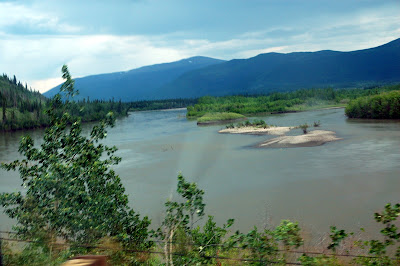
Our drive today literally had lots of ups and downs and we passed many, many rivers, lakes and high mountain views. A lot of the Klondike highway runs up high on the side of mountains and it provides terrific views of the mountains and valleys. Some of the valleys are miles wide. It is truly majestic! You look across the valley and see a lake or river, millions of trees, and no sign of civilization - no houses, electric lines, nothing!
After a lunch stop we journeyed on to Dawson City with brief stops and Moose Creek Lodge and the Tintina Trench. At the moose lodge we caught a glimpse of the only "wildlife" we saw today. It was a wooden moose, caribou and deer created by the lodge owner. The only wild part of each was the antlers! The Tintina Trench is a vast valley that runs several hundred miles through Alaska and the Yukon. It was created when the islands and land masses in the northern Pacific collided with the North American continent. A huge fault like lies under the trench which is miles wide. The trench makes a natural migratory path for birds that migrate in the fall and spring. They fly through the trench because there are no mountains to fly over or around. And you thought birds were dumb animals!!
We got to Dawson City and our RV park about 4:30. Everyone in the park came out to watch us pull in and park. Spaces here are all back-in and are only 18 ft. wide. We are once again stacked in here like chordwood. However, you have to understand, these places are only open a few months out of the year and they have to make as much as they can in that short time. Thanks to Gene, on of our caravaners, we were able to get into our spot on the first attempt. He gives explicit directions on how to back, where to start, what direction and when to turn the wheel. So easy!! The first major mechanical problem for our caravan occurred on this leg of the trip. Chris and Carl Finley's "toad" - the car they pull behind their motorhome - had the brakes lock up. Consequently, they had two blowouts and lost the rims also. Finding tires was not so hard, but I imagine finding 2 new rims in this part of The Yukon would prove difficult.
I needed propane and diesel so I went to the only station in town. As luck would have it, their electricity was off and I couldn't get either. Thanks to Robert I was able to borrow a tank of propane so we could have dinner. Hope they have power tomorrow!
Tomorrow is a trip to Dome Mountain where you are high enough to see the sun set and rise at the same time - if you are there at the right time. We also have a tour of Dawson City. I'll let you know how things go. Till then, Happy Trails!
Subscribe to:
Posts (Atom)